Library Contents Search the Library RV Tech Library Help Page Site Map About Us Tiffin RV Network TRVN Classifieds Campground Reviews Photo Gallery TRVN Store
Appliances Batteries Boondocking/Dry Camping Chassis Clubs & Forums Electrical Electronics Engines Exterior Maintenance Generators Heating & Air Conditioning Interior Maintenance Misc Items Operating Tips Plumbing Red Bay Safety & Health Storage Supplier Contacts Tires and Wheel Rims Towing Transmissions Weighing

How Do GPS Systems Work?
What is GPS?
Originally conceived as a navigation aid for the military, the Global Positioning System, or GPS, has since grown from relatively humble beginnings as different supporting technologies have been developed, some of which are within reach of consumer budgets.
All that GPS does is provide a set of coordinates which represent the location of the GPS unit with respect to it’s latitude, longitude and elevation on planet Earth. It also provides time, which is as accurate as that given by an atomic clock.
The actual application of the GPS technology is what leads to such things as navigation systems, GPS tracking devices, GPS surveying and GPS mapping. GPS in itself does not provide any functionality beyond being able to receive satellite signals and calculate position information. But it does that very well!
Trilateration Basics
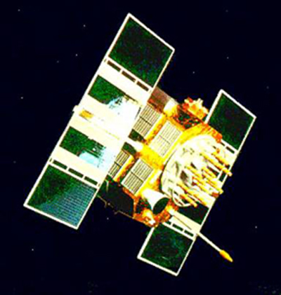
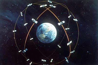
When people talk about "a GPS," they usually mean a GPS receiver. The Global Positioning System (GPS) is actually a constellation of 27 Earth-orbiting satellites (24 in operation and three extras in case one fails). The U.S. military developed and implemented this satellite network as a military navigation system, but soon opened it up to everybody else.

Photo courtesy NASA
NAVSTAR GPS satellite
Each of these 3,000- to 4,000-pound solar-powered satellites circles the globe at about 12,000 miles (19,300 km), making two complete rotations every day. The orbits are arranged so that at any time, anywhere on Earth, there are at least four satellites "visible" in the sky.

Photo courtesy U.S. Department of Defense
Artist's concept of the GPS satellite constellation
The GPS receiver's job is to locate four or more of these satellites, figure out the distance to each, and use this information to deduce its own location. This operation is based on a simple mathematical principle called trilateration. Trilateration in three-dimensional space can be a little tricky, so we'll start with an explanation of simple two-dimensional trilateration.
2-D Trilateration
That takes a bit to get your tongue around doesn‘t it! Imagine you are somewhere in the United States and you are TOTALLY lost -- for whatever reason, you have absolutely no clue where you are. You find a friendly local and ask, "Where am I?" He says, "You are 625 miles from Boise, Idaho." This is a nice, hard fact, but it is not particularly useful by itself. You could be anywhere on a circle around Boise that has a radius of 625 miles.
You ask somebody else where you are, and she says, "You are 690 miles from Minneapolis, Minnesota." Now you're getting somewhere. If you combine this information with the Boise information, you have two circles that intersect. You now know that you must be at one of these two intersection points, if you are 625 miles from Boise and 690 miles from Minneapolis. If a third person tells you that you are 615 miles from Tucson, Arizona, you can eliminate one of the possibilities, because the third circle will only intersect with one of these points. You now know exactly where you are -- Denver, Colorado.
This same concept works in three-dimensional space, as well, but you're dealing with spheres instead of circles. In the next section, we'll look at this type of trilateration.
3-D Trilateration
Fundamentally, three-dimensional trilateration isn't much different from two-dimensional trilateration, but it's a little trickier to visualize. Imagine the radii from the examples in the last section going off in all directions. So instead of a series of circles, you get a series of spheres. If you know you are 10 miles from satellite A in the sky, you could be anywhere on the surface of a huge, imaginary sphere with a 10-mile radius. If you also know you are 15 miles from satellite B, you can overlap the first sphere with another, larger sphere. The spheres intersect in a perfect circle. If you know the distance to a third satellite, you get a third sphere, which intersects with this circle at two points. The Earth itself can act as a fourth sphere -- only one of the two possible points will actually be on the surface of the planet, so you can eliminate the one in space. Receivers generally look to four or more satellites, however, to improve accuracy and provide precise altitude information. In order to make this simple calculation, then, the GPS receiver has to know two things:
-
The location of at least three satellites above you
-
The distance between you and each of those satellites
The GPS receiver figures both of these things out by analyzing high-frequency, low-power radio signals from the GPS satellites. Better units have multiple receivers, so they can pick up signals from several satellites simultaneously.
Want to know more about the GPS system as well as read about various GPS units? For all you ever wanted to know about GPS go to the following website:http://gpsinformation.net
Submitted by Mike Sundberg - 2/08/06
Click Your browser's "Back" button to return to the previous page
or chose another category from the side menu.
The RV Tech Library is brought to you by the TiffinRVnetwork
Absolutely No Affiliation exists between this group and Tiffin Motor Homes Inc or the Allegro Club. This website neither endorses or discourages the use or purchase of a Tiffin product. All references, suggestions, comments, etc. contained herein are the opinions/experiences of the posters and not those of Tiffin Motor Homes Inc. or the website administrators.


